North Atlantic CurrentsThe North Atlantic Ocean is dominated by the NORTH EQUATORIAL CURRENT and the GULF STREAM SYSTEM.NORTH EQUATORIAL CURRENT.— 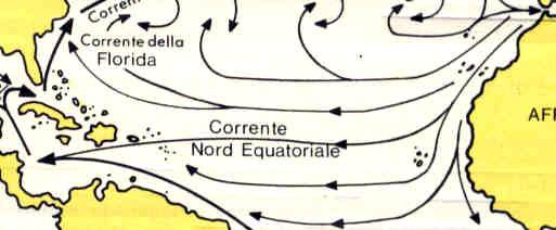 The North Equatorial Current is located in the trade wind belt (zona) of the North Atlantic Ocean. The chief sources of the flow are the northeasterly currents off the west coast of northwestern Africa. These currents of water of relatively high density and low temperature are an extension of the North Atlantic Current. They help lower the temperatures along the northwest coast of Africa. The temperatures near the coast are further lowered by UPWELLING. Upwelling of ocean water is a process by which winds push surface water away from the coast. Colder subsurface water then moves up and replaces the surface water. In the Northern Hemisphere, upwelling is common where the wind blows parallel to the coast, with the coast on the left side of the wind. The upwelling process affects only the upper layers of the ocean (the maximum depth being about 150 fathoms or 900 feet). The North Equatorial Current is located in the trade wind belt (zona) of the North Atlantic Ocean. The chief sources of the flow are the northeasterly currents off the west coast of northwestern Africa. These currents of water of relatively high density and low temperature are an extension of the North Atlantic Current. They help lower the temperatures along the northwest coast of Africa. The temperatures near the coast are further lowered by UPWELLING. Upwelling of ocean water is a process by which winds push surface water away from the coast. Colder subsurface water then moves up and replaces the surface water. In the Northern Hemisphere, upwelling is common where the wind blows parallel to the coast, with the coast on the left side of the wind. The upwelling process affects only the upper layers of the ocean (the maximum depth being about 150 fathoms or 900 feet).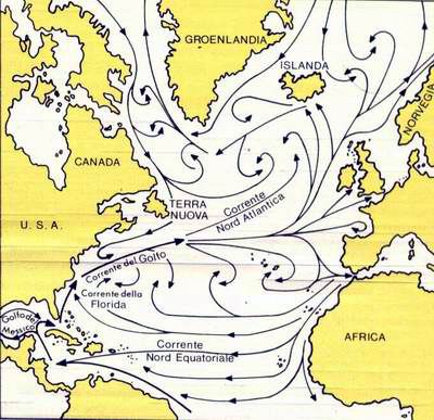 As the North Equatorial Current flows westward north of the equator, the South Equatorial Current crosses the equator and joins it in the western North Atlantic Ocean. Consequently, that part of the North Equatorial Current that enters the Caribbean Sea has water that is a mixture of waters from the North Atlantic Ocean and South Atlantic Ocean. As the North Equatorial Current flows westward north of the equator, the South Equatorial Current crosses the equator and joins it in the western North Atlantic Ocean. Consequently, that part of the North Equatorial Current that enters the Caribbean Sea has water that is a mixture of waters from the North Atlantic Ocean and South Atlantic Ocean.
ANTILLES CURRENT. —The Antilles Current is the western extension of the North Equatorial Current. It flows along the northern side of the Greater Antilles. It carries water that is virtually the same as that of the Sargasso Sea (a portion of the middle North Atlantic Ocean).GULF STREAM SYSTEM. —The Gulf Stream system begins in the Florida Straits and flows northward and eastward along the east coast of the United States. This system, along with the Kuroshio System of the western Pacific, is the fastest of all the ocean currents. It moves with speeds of 25 to 75 miles per day or roughly 1 to 3 knots. The Gulf Stream system is made up of three currents: the FLORIDA CURRENT, GULF STREAM, and NORTH ATLANTIC CURRENT.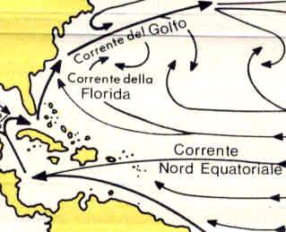 Florida Current. —The Florida current extends from the Florida Straits to Cape Hatteras. Much of the flow is derived from the Caribbean Sea by way of the Yucatan Channel; the water from the Yucatan Channel takes the shortest route to the Florida straits rather than making a long sweep through the Gulf of Mexico. The Florida Current is also fed by the Antilles Current. Florida Current. —The Florida current extends from the Florida Straits to Cape Hatteras. Much of the flow is derived from the Caribbean Sea by way of the Yucatan Channel; the water from the Yucatan Channel takes the shortest route to the Florida straits rather than making a long sweep through the Gulf of Mexico. The Florida Current is also fed by the Antilles Current.
Oceanographers believe that the energy of the Florida Current comes from the difference in the levels of the water in the Gulf of Mexico and the water adjacent to the Florida coast, the waters in the Gulf being higher. The difference in the two levels is due to the prevailing winds which result in the piling up of water in the Gulf of Mexico.Gulf Stream. —The Gulf Stream is the middle portion of the Gulf Stream System. It begins near Cape Hatteras and continues north-ward to the vicinity of the Grand Banks off Newfoundland. To the right of the Gulf Stream is the Sargasso Sea portion of the North Atlantic Ocean, and to the left are coastal and slope waters.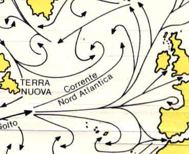 North Atlantic Current. —The North Atlantic Current begins off the Grand Banks, where the Gulf Stream begins to fork. It consists of northerly and easterly currents terminating in subsidiary currents. One of the major subsidiaries is the IRMINGER CURRENT, which flows westward off the southern coast of Iceland. Another is the NORWEGIAN CURRENT. It flows beyond the Norwegian Sea into the polar seas. Other branches of the North Atlantic Current, turning southward, end in huge eddies off the coast of Europe and in the relatively cold CANARIES CURRENT off the northwest coast of Africa. North Atlantic Current. —The North Atlantic Current begins off the Grand Banks, where the Gulf Stream begins to fork. It consists of northerly and easterly currents terminating in subsidiary currents. One of the major subsidiaries is the IRMINGER CURRENT, which flows westward off the southern coast of Iceland. Another is the NORWEGIAN CURRENT. It flows beyond the Norwegian Sea into the polar seas. Other branches of the North Atlantic Current, turning southward, end in huge eddies off the coast of Europe and in the relatively cold CANARIES CURRENT off the northwest coast of Africa.
Note: | 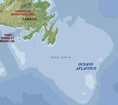 Area eccezionalmente pescosa dell'oceano Atlantico settentrionale, caratterizzata da acque poco profonde, situata al largo della Terranova sudorientale (Canada); è costituita da una serie di rilievi sottomarini che s'innalzano dalla piattaforma continentale e si estende per circa 560 km, con una profondità generalmente compresa tra i 37 e i 183 m. La fredda corrente del Labrador attraversa buona parte della zona, mentre la calda corrente del Golfo scorre lungo la parte orientale della zona stessa: l'unione delle due correnti, insieme alla scarsa profondità dell'acqua, fornisce un ambiente favorevole per il plancton, che costituisce l'alimento principale dei pesci. Per questa ragione da più di mezzo secolo Grand Banks è una delle aree oceaniche più pescose del mondo, con varie specie di pesce: merluzzo, eglefino, aringa e sgombro. Nel XX secolo, tuttavia, l'eccessivo sfruttamento delle risorse ittiche ha reso necessari dei provvedimenti per proteggere le riserve, tra cui una netta diminuzione dei quantitativi pescabili. Ciò ha provocato delle tensioni internazionali: un esempio è costituito dall'incidente avvenuto nel marzo 1995, quando le autorità canadesi sequestrarono un motopeschereccio spagnolo che aveva superato la quota stabilita dall'Unione Europea per l'ippoglosso (halibut) della Groenlandia. La zona è spesso avvolta da una fitta nebbia. Area eccezionalmente pescosa dell'oceano Atlantico settentrionale, caratterizzata da acque poco profonde, situata al largo della Terranova sudorientale (Canada); è costituita da una serie di rilievi sottomarini che s'innalzano dalla piattaforma continentale e si estende per circa 560 km, con una profondità generalmente compresa tra i 37 e i 183 m. La fredda corrente del Labrador attraversa buona parte della zona, mentre la calda corrente del Golfo scorre lungo la parte orientale della zona stessa: l'unione delle due correnti, insieme alla scarsa profondità dell'acqua, fornisce un ambiente favorevole per il plancton, che costituisce l'alimento principale dei pesci. Per questa ragione da più di mezzo secolo Grand Banks è una delle aree oceaniche più pescose del mondo, con varie specie di pesce: merluzzo, eglefino, aringa e sgombro. Nel XX secolo, tuttavia, l'eccessivo sfruttamento delle risorse ittiche ha reso necessari dei provvedimenti per proteggere le riserve, tra cui una netta diminuzione dei quantitativi pescabili. Ciò ha provocato delle tensioni internazionali: un esempio è costituito dall'incidente avvenuto nel marzo 1995, quando le autorità canadesi sequestrarono un motopeschereccio spagnolo che aveva superato la quota stabilita dall'Unione Europea per l'ippoglosso (halibut) della Groenlandia. La zona è spesso avvolta da una fitta nebbia.
|
|