THE THREE-LAYERED OCEAN A convenient method of visualizing the sea is to divide it into layers in much the same way that we do the atmosphere. Using bathythermograph information (temperature versus depth profiles), the oceans display a basic three-layered structure: the mixed layer, main thermocline, and deep water layer. The latitudinal distribution of these layers is shown in figure 1-2-1, while the typical thermal structure is shown in figure 1-2-2. Both figures are representative of winter.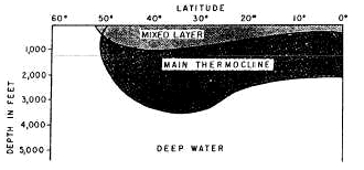
Figure 1-2-1.—North-south distribution of a simple three-layered ocean (North Atlantic) in winter.Figure 1-2-2.-Typical thermal structure of the oceans (winter conditions in mid-latitudes). | 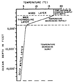
|
The mixed layer is the upper layer of the three-layered ocean model. It is a layer of fairly constant warm temperatures which, in middle latitudes, extends from the surface to a maximum depth of about 450 meters, or 1,500 feet. This layer gets its name from the mixing processes that bring about its fairly constant warm temperatures. The two mixing processes are classified as mechanical and convective. MECHANICAL MIXING. —This mixing process is caused by wave action, surface storms, etc. The wave action stirs up the water. Warmer surface water is driven downward, where it mixes with colder subsurface water. Eventually, a layer of water with a fairly constant temperature is produced. This process is more important in summer than in winter, because surface waters are much warmer and less dense than sub-surface waters, thereby producing a stable water column. The mechanical mixing process is more rapid and irregular than the convective mixing process.CONVECTIVE MIXING. —This process occurs as a result of changes in water stability. When surface waters become more dense than subsurface waters, an unstable condition exists. Such a condition can occur when there is an increase in surface salinity owing to evaporation or the formation of ice, or by a decrease in the surface water temperature. A temperature decrease of .01°C or a salinity increase of 0.01 ‰, is sufficient to initiate the convective mixing process. In the former case, for example, a cold polar or arctic air mass moving over warm water cools the surface water before it can cool the subsurface water. As the surface waters cool and become colder than the subsurface waters, they become more dense and sink. As the colder surface water sinks, the warmer and less dense subsurface water rises to the surface to replace it. This process continues until the water is thoroughly mixed, the density difference eliminated, and the water column stabilized. Even though winds and the resultant wave action are generally stronger during winter, convective mixing, caused by the colder winter air temperatures, produces a deeper mixed layer than can be attained by mechanical mixing. It is for this reason that convective mixing is considered the more important of the two, and the predominant process of winter. The convection process is strongest in northern waters where vertical temperature and salinity gradients are not extreme and surface waters undergo a high degree of cooling. Convective mixing attributed to salinity changes is most noticeable in the Mediterranean and Red seas, where evaporation far exceeds precipitation. We have looked at both processes individually; however, the two processes can and often do take place simultaneously. When this occurs, the mixed layer normally attains a greater depth than would be attained by either process individually.
The main thermocline is the central layer of the ocean. It is found at the base of the mixed layer and is marked by a rapid decrease of water temperature with depth. SEASONAL THERMOCLINE. —At high latitudes there is no marked change in water temperature with the seasons, while in the mid-latitudes, a seasonal thermocline develops with the approach of summer. This seasonal thermocline comes about from the gradual warming of the surface waters. The warming takes place in the upper few hundred feet of the surface, and results in the seasonal thermocline becoming super-imposed on the main thermocline. Figure 1-2-3 illustrates the development of the seasonal thermocline in the mid-latitudes. The mid-latitude summer thermocline is more pronounced than the thermocline of spring or autumn. Bathythermograph traces of the summer thermocline show that it affects a much broader range of depth than at any other time of year. In our illustration, the seasonal thermocline is roughly 35 meters thick (90 to 125 meters deep). Note, also, that the winter temperature profile shows no seasonal thermocline. The mixed layer extends to a depth in excess of 160 meters. 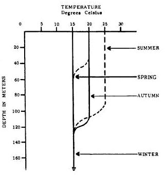 Come spring, the surface water is warmed and a seasonal thermocline develops between 35 and 60 meters. As summer takes hold, the water warms to 25°C and the mixed layer extends to a depth of approximately 90 meters. The thermocline now exists between 90 and 125 meters. In summer, the seasonal thermocline is deeper and covers a broader range of depth than at any other season of the year. With the approach of autumn, the mixed layer continues to drive the thermocline deeper, but the water within the mixed layer is cooler than it was in summer. Just as in the spring, the cooler water in the mixed layer decreases the range of depths covered by the thermocline. In low latitudes, small seasonal temperature changes make it difficult to distinguish between the seasonal and the permanent thermoclines. Come spring, the surface water is warmed and a seasonal thermocline develops between 35 and 60 meters. As summer takes hold, the water warms to 25°C and the mixed layer extends to a depth of approximately 90 meters. The thermocline now exists between 90 and 125 meters. In summer, the seasonal thermocline is deeper and covers a broader range of depth than at any other season of the year. With the approach of autumn, the mixed layer continues to drive the thermocline deeper, but the water within the mixed layer is cooler than it was in summer. Just as in the spring, the cooler water in the mixed layer decreases the range of depths covered by the thermocline. In low latitudes, small seasonal temperature changes make it difficult to distinguish between the seasonal and the permanent thermoclines.
Figure 1-2-3.-Upper level thermal structure of seasonal thermocline in middle latitudes. The deep water layer is the bottom layer of water, which in the middle latitudes exists below 1,200 meters. This layer is characterized by fairly constant cold temperatures, generally less than 4°C. To better understand the basic vertical temperature distribution, look once again at figure 1-2-1. At high latitudes in winter, the water is cold from top to bottom. The vertical temperature profile is essentially isothermal (no change in temperature with depth). In middle latitudes, the structure is like that illustrated in figure 1-2-2. In low latitudes, the mixed layer extends to a depth of about 300 feet. Here, the main thermocline is encountered and the temperature drops about 8°C more than it does in the mid-latitudes. This sharper drop is due to the higher surface temperature in the lower latitudes. The thermocline extends to 2,100 feet, where the deep layer is encountered.
|